Tuesday, April 28, 2009

Module 11: Google Earth


Average wind speed at Station MKGM4 at Muskegon, MI (to the northeast of site) is 11 knots (12.7 mph)with gusts of 15 knots (17.3 mph). It's beyond the BERR recommended 200 to 300 meter distance fromdwellings to minimize noise pollution. It is also beyond the BERR recommended 400 to 800 meter distance to avoid adverse reactions to Shadow Flicker. Major shipping routes out of Chicago and Milwaukee are to the southwestand west, respectively. The site is a good compromise with regards to major bird migration corridors,and should be minimally impactful to most species. Its proximity to land should help minimize buildingand transportation costs.

Saturday, April 25, 2009

Before and After


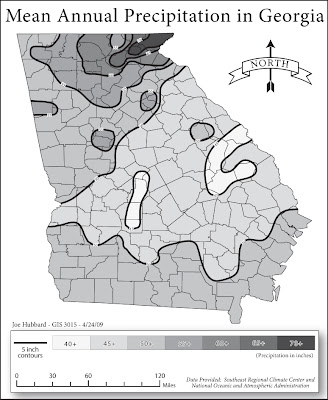
I drew my isolines as closed loops that went beyond the boundaries of the state. That's what you see in the first picture. I used the pencil tool, and once they were complete I clicked on the path and set the stroke and fill as normal. I used ColorBrewer to come up with the grayscale. After drawing all my isolines, I created shapes with the pen tool to conceal the portions of the isolines that went beyond the edge of the Georgia map. You can see the concealing shapes in the bottom photo. I changed their stroke to black so they would be visible. You will have to change the fill of the Georgia map from that beigey/orangey color to No Fill and make sure it is in a layer above the isoline shapes.

It becomes an exercise in setting up Layers appropriately. It's a bit slow (and tedious). I'm sure there's a more efficient method to do it, but I have not puzzled it out. Good luck!

Sunday, April 12, 2009

Module 9: Flow Maps


Maximum stroke size was 30 points. I grouped Antartica into the Unknown category and added the question mark circle to indicate unknown countries of origin. I also did not include Alaska or Hawaii. Since I'm only showing immigration to the country itself and not to individual states it seemed unnecessary to add anything beyond the contiguous U.S.

Friday, April 10, 2009

Module 8: Contiguous Cartograms


I'm not at all sure about the legend. I wanted to convey that the countries with the greatest increase in size indicated a greater GDP. I used a divergent color scheme to further highlight which countries had higher GDP's. The size increase from the cartogram application made it easy to see which countries had higher GDP's, if I was familiar with the geography. But, a country like South Africa, whose actual shape I'm not terribly familiar with was difficult to determine at a glance.

Failed to include the number of iterations I used. It was 8.

Module 8: Non-Contiguous Cartograms


The biggest problem I had with this map was the projection. If I applied the Robinson World projection, or any other world projections, prior to running the cartogram application, the cartogram output would be at such a large scale it was imperceptible on the small scale world map. I applied the GCS 84, ran the cartogram, then added the Robinson projection. The GCS 84 gives Alaska a stretched out look. The Robinson projection looks more like I expect the world to look. I was guessing on this legend as well. I used the 5 color divergent scheme here, too. So, I added 5 circles. They are only representative of circles that would fall in each division. I prefer the contiguous map. It makes more sense to me visually. In particular, the non-contiguous map is very confusing to look at without the further differentiation a color scheme provides. I made the circles slightly translucent to reveal the base map beneath. It's a bit gaudy looking.


Wednesday, April 1, 2009

Module 7: Dot Distribution Map


I ended up using a dot value of 3, 1 dot is 3 houses per square mile. I used a dot size of 0.6 points, but later added a stroke of 0.2 points. I choose not to display county names, rivers, lakes, or wetlands so the dots would stand out. I found the map very busy looking with all layers displayed. Plus, I had so much fun making 2289 blue dots I just had to show them off :)